
Page 7 - Nov/Dec Vol34 No5
P. 7
some areas, the boardwalk is at grade on with the South Chickamauga Alliance, a section. During early route planning, the
the high/uphill side, and 30 feet high on group that represents citizens who advocate pathway was routed under an existing
the low/downhill side. for the protection, preservation, conserva- CSX railroad and then almost immedi-
tion, and improvement of the watershed. ately over the aerial sewer crossing. In
The sloped, heavily wooded terrain The design team met with this organization order to achieve the necessary clearance
presented several challenges during the to solicit input for the project. Another under the railway, the boardwalk was
alignment design process. There was significant issue was proximity of the trail driven down to an elevation which could
limited survey data locating large exist- to the creek. The design maintains a vegeta- not be adjusted quickly enough to avoid
ing trees, and the final trail alignment was tive buffer and riparian zone between the conflict of the sewer structure crossing
established in the field during construc- creek and trail sections to minimize impact the creek and the boardwalk. Barge Wag-
tion by the project team. This hands-on to the land, and to protect the waterway. goner quickly understood the constraint
process allowed for maximum flexibility Areas of boardwalk allowed for very low- this conflict presented for the project and
to avoid specimen hardwood trees, rock impact clearing along the creek stream realized that any adjustments to the ex-
bluffs, and other natural features identi- edges and vegetation. isting road and bridge structure would be
fied for preservation. cost prohibitive for the project. By using
At the present time, Barge Waggoner an iterative design approach, Barge Wag-
Because the trail crosses under City has been engaged by The Trust for Public goner rerouted the trail from underneath
streets and active railroads, these locations Land to complete design for portions of the the CSX crossing to a location where the
presented opportunities for creative de- remaining 3-mile section required to final- trail can cross the sewer. This new loca-
sign. The design under Bonny Oaks Drive ize the connection from the River Park to tion is at the point the sewer transitions
needed to maintain proper head clear- Camp Jordan. This section includes similar from the aerial crossing into the bank of
ance and keep the low chord of the bridge characteristics and will require some of the stream.
above the 100-year flood elevation. A same design solutions utilized in earlier
covered walkway under a railroad protects phases, but uniquely encounters railroad The trail has been described by past
users from potential falling debris from underpasses and an elevated sewer creek users as a “walk in the trees” that al-
the tracks above, with the design offering crossing in close proximity to each other. lows some peaceful time away from life’s
safety combined with aesthetic appeal. These obstructions are made more difficult demands in an urban environment. South
by steep banks on each side of the creek, Chickamauga Creek’s transformation over
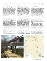
One of the main goals was to determine which limits viable options to maintain an the last 20 years and its connection to
a way that traverses the difficult terrain ADA accessible walkway. the Riverwalk provides the surrounding
without destroying the natural beauty community an enhanced experience that
of existing plant communities along the The constraints in this portion of the encourages recreation for all ages, and
creek. The elevated boardwalk provided project have required Barge Waggoner ultimately provides a trail system over 20
the desired accessibility with minimal im- to perform extensive on-site reviews and miles long from East Ridge to the foot of
pact to the existing vegetation and steep field surveys in order to evaluate and Lookout Mountain near downtown.
topography. design a constructible, cost-effective trail
Barge Waggoner also worked closely
View online at tnpublicworks.com 7