
Page 25 - May-June 2017 Vol. 35 No.1
P. 25
TCAPWA EVENTS AND HIGHLIGHTS
West Branch Meets in Collierville By John Fox
Meeting held at Historic 180-degree panoramic
Morton Museum street level imagery
with unique images
The TCAPWA’s West Branch held its that include precise
quarterly meeting on March 28 at the geospatial attributes
Collierville Morton Museum situated in associated with each
Collierville’s Historic Downtown area. digital pixel collected.
In cooperation with the Morton Mu- Madrid explained
seum and sponsored by CycloMedia, the how the information
TCAPWA branch meeting was a great collected is used as
success with over 45 members and guests a visual database of
in attendance. TCAPWA officers and geographic informa-
past officers in attendance included Past tion to support and
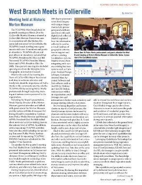
TCAPWA Presidents Bill Kilp and Bill enhance existing Above: Over 45 Public Works professionals and guests attended the West
Yearwood, TCAPWA President Manny Branch meeting at Historic Morton Museum in Collierville. Below: Screen
Belen and APWA President-Elect Bo
Mills. This quarter’s meeting also included Geodatabase systems. shot of the CycloMedia system.
special guests from the Memphis Area Madrid showed how
Geographic Information Counsel. integrating with vari-
ous existing business
Prior to the start of the meeting the systems such as Com-
Town of Collierville’s Mayor Stan Joyner puter Assisted Design
took time to welcome attendees and software, Computer
briefly talk about the importance of Public Assisted Mass Ap-
Works in the community and the role the praisal Software and
TCAPWA fills by assisting Public Works Esri software such as
professionals through leadership, train- ArcGIS for Desktop
ing and various events sponsored by the and ArcGIS Online,
organization. various users within
an organization could
Following the Mayor’s presentation, leverage data and
Brook Mundy, Director of the Morton information to better track, inventory, and able to streamline workflows and commu-
Museum, greeted attendees and talked manage existing infrastructure items. nication throughout their organizations.
with guests about the Morton Museum By overlaying shapefiles and feature CycloMedia’s image quality also allows
and the various exhibits showcased. Fol- classes on top of a GeoCyclorama, the Assessors to zoom in and assess the grade
lowing Mundy’s presentation, German- GeoCyclorama system can be used by and condition of residential properties,
town Public Works Director and National planners and decision makers with accu- verify addresses, and take accurate mea-
APWA President-Elect Bo Mills talked rate asset visualization and location veri- surements to provide detailed information
about news and activities taking place on fication. Because each pixel has X, Y, and during court appeals.
the national level of APWA. In addition, Z data associated with it, highly accurate LIDAR data collected at the ground level
several upcoming TCAPWA activities measurements can be taken that include at the same time Street Level imagery is
were also discussed including the upcom- height, width, area, slope and volume. collected also provides tight integration of
ing Tennessee Public Works Institute Madrid discussed how GIS profession- LIDAR and GeoCyclorama Imagery that
courses and the upcoming TCAPWA/ als and professionals who leverage GIS gives the user a long list of capabilities that
SWANA Conference scheduled for No- also have the capability to extract features can be leveraged in many other projects.
vember 7-9 in Knoxville. and other useful information from a Geo- Leveraging CycloMedia Technology has
Cyclorama enabling them to accomplish also proven essential during vegetation
The speaker for this quarter’s meeting tasks more efficiently as well as accurately management projects. With the combina-
was Paul Madrid from CycloMedia who updating their Geo Data Base at the same tion of GeoCycloramas, LIDAR Data and
presented information on Infrastructure time. With the ability to travel through ArcGIS, city managers can give specific
and Asset Management utilizing GeoCy- city and county streets from an office and details about where vegetation is inter-
cloramas (Street Level Imagery) and how the ability to make decisions based on fering with powerlines. This knowledge
new breakthroughs in technology allow information collected from GeoCyclo- allows managers to assign specific tasks to
Public Works professionals to perform rama Imagery, users are able to save time, contractors about where vegetation needs
various infrastructure related tasks more money, resources and improve the safety managing.
effectively and efficiently than ever before. of field crews. The capabilities and geospatial accuracy
In addition, by sharing this important of CycloMedia’s GeoCycloramas have
During his presentation, Madrid talked decision making information between proven time and again to enhance the
about CycloMedia’s GeoCylcorama imag- departments and teams, users are also
ery system, a high quality 360-degree-by- Continued on page 26
View online at tnpublicworks.com 25